Fourth in the world
South Australia ranks fourth in the world, and first in Australia, for mining investment attractiveness in the Fraser Institute’s 2025 survey of mining companies. It also ranks first on the survey’s mineral potential index.
 Fission RidgePty Ltd
Projects
Two granted licences at Mulpula and one application at Gason, along the Birdsville Track in South Australia’s far north-east, 160 to 195 km north-east of Marree.
Floodwater in Cooper Creek reaching Kati Thanda-Lake Eyre, June 2025. Image: NASA Earth Observatory.
The district
Beneath the flat gibber and dune country of the Eromanga Basin lies the Birdsville Ridge, a buried basement structure that extends the crustal-scale deformation corridor along which South Australia’s uranium deposits lie.
The basin has been explored for petroleum for decades, leaving seismic, gravity, magnetic and radiometric coverage over the district. Fission Ridge has re-modelled that data for uranium and copper-gold. The target areas themselves have never been explored for uranium, and past tenure over the ground was desktop-only or never worked.
More than 100 km of interpreted roll-front uranium trend, never tested.
The geological interpretation
Cretaceous sandstones, shales and coal horizons, overlain by Tertiary sandstones: permeable oxidising units against reduced ones, the pairing that forms and traps roll-front uranium.
The basin overlies basement with high radiogenic heat production, and long-lived hydrothermal and meteoric fluids have leached uranium from it.
Aquifers overlie major basement faults. Fission Ridge is targeting district-scale basement faulting and dome development in the same sediments.
Airborne U²/Th radiometrics show uranium anomalies. Thorium does not move, so the ratio strips out false positives from mobile uranium: direct evidence of uranium in the system.
Sentinel-2 ferric-iron imagery shows a strong match between oxidised sediments and the uranium anomalies.
South Australian Government 3D seismic modelling maps the key contact between oxidised sandstones and the overlying shale, a major onlap break, and major structural intersections.
About a third larger in footprint than Olympic Dam’s own gravity response.
About 15 km across and 8 mGal in amplitude, supported by nine semi-regional gravity stations and modelled at 450 to 500 m depth. It remains untested.
Olympic Dam, the type example of an iron oxide copper-gold-uranium deposit, shows as a gravity high. The Gason anomaly’s footprint is about a third larger. Its lower amplitude fits a source roughly 200 m deeper: about 500 m, against about 300 m at Olympic Dam.
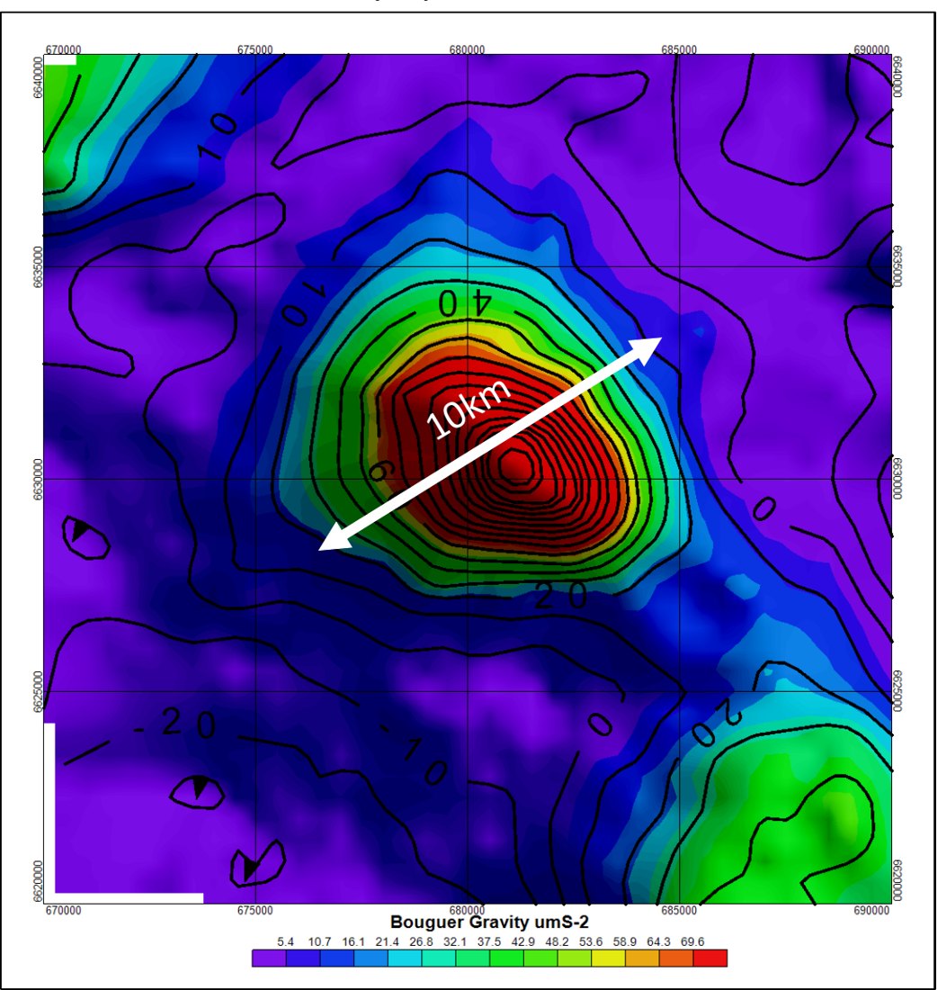
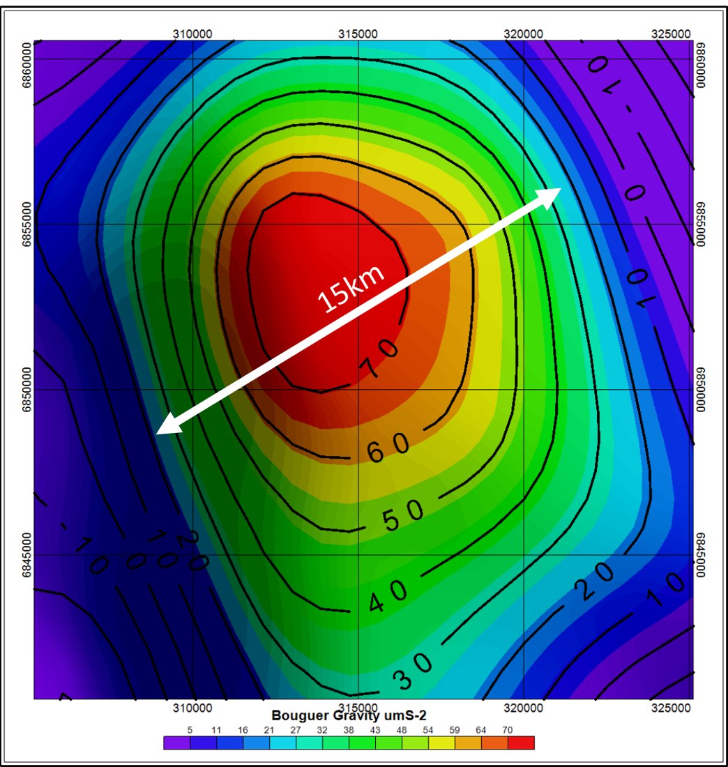
Bouguer gravity, shown side by side at similar colour scales. Images: Fission Ridge.
Tenure and access
Mulpula exploration licences EL 7169 and EL 7170 were granted effective 4 November 2026. Gason application ELA01275, lodged on 31 August 2026, remains an application. Current tenement information is available through the MERS Portal.
South Australia ranks fourth in the world, and first in Australia, for mining investment attractiveness in the Fraser Institute’s 2025 survey of mining companies. It also ranks first on the survey’s mineral potential index.
The state government co-funds drilling, geophysics, research and data work through PACE Minerals, its Plan for Accelerating Exploration, with a 2026-27 funding round now open.
The Geological Survey of South Australia makes decades of drilling, geophysical and survey data freely available through SARIG. The same survey ranks the state third in the world for its geological database.
South Australia has mature legal frameworks and established Indigenous Land Use Agreements and agreement processes, giving explorers a clear pathway to access while protecting Aboriginal cultural heritage.
Sources: Fraser Institute, Annual Survey of Mining Companies 2025; Department for Energy and Mining, Government of South Australia.